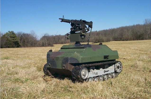
Robot vehicles are only as useful as their ability to find a way forward. Communications links fail, maps go stale. Carmenta, a geospatial software manufacturer, says it has a remedy.
The Sweden-headquartered company has integrated its terrain router with a robot operating system. The integration lets uncrewed ground vehicles (UGVs) recalculate routes onboard during missions. It combines terrain data, tactical constraints, and real-time observations. Carmenta says this helps vehicles adapt to changing conditions. It argues that the result is better mobility and improved survivability in contested environments. For the latter, read war.
The pitch rests on lessons from the war in Ukraine. Terrain accessibility, obstacles, and tactical conditions can change fast during a mission, Carmenta says. Armies therefore want autonomous systems that cope without continuous communications. The firm argues that this need is growing as UGVs spread through military operations.
Technically, Carmenta has linked its terrain routing to ROS 2 Navigation 2, known as Nav2. This is a widely used open-source autonomy framework. The link puts advanced terrain-aware route planning directly inside the vehicle’s autonomy stack. Routes can then change as new information arrives.
Beyond the next obstacle
Tobias Moberg, CTO at the company, draws a distinction between two kinds of navigation. “Autonomous vehicles are already good at avoiding obstacles and navigating locally, but mission-level route planning needs to consider more than just the local environment,” he said.
Mr Moberg described what onboard routing adds. “By bringing tactical routing onboard, vehicles can continuously reassess their route using both geospatial intelligence and observations from the operational environment,” he said. That is the core of the product.
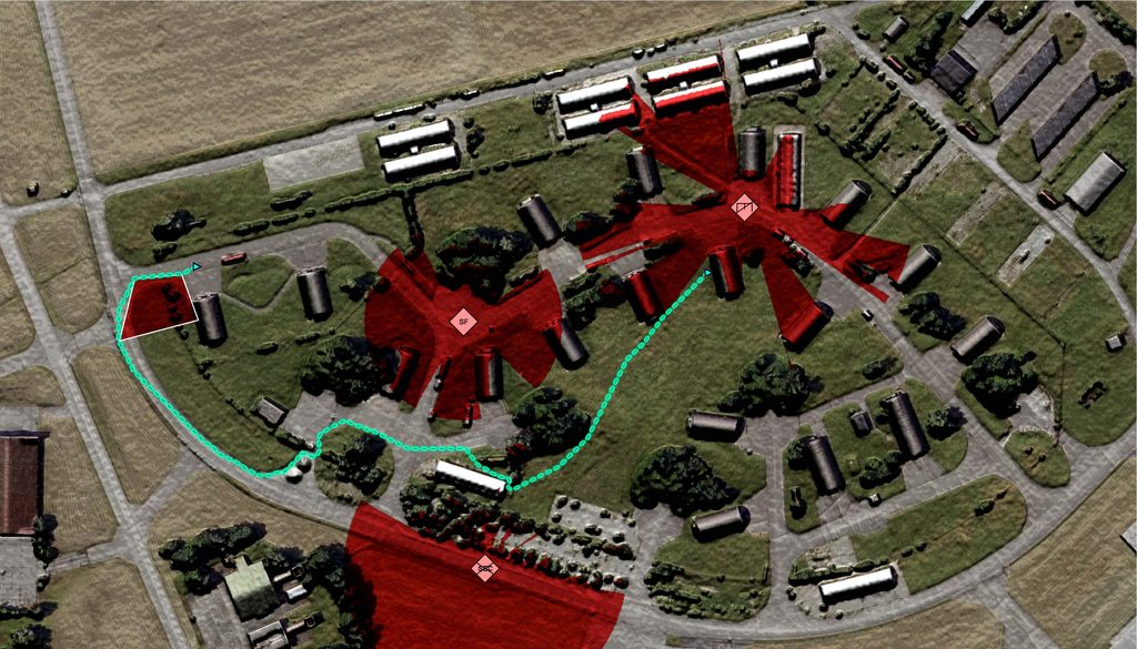
The route calculations combine geospatial data, mission objectives, and tactical considerations. These include no-go areas, enemy observation and engagement zones, and preferred movement corridors. Onboard sensors can update every one of these factors continuously. The route therefore shifts as the picture changes.
The system also learns from the ground. When a vehicle meets terrain that differs from its map, that observation can influence later route calculations. Subsequent choices improve. The information can also pass to other platforms in the same area, giving a whole fleet a more current view of terrain.
What Nav2 does, and does not
Nav2 is the navigation framework for ROS 2 mobile robots. It turns a navigation goal into motion. It combines localisation and map inputs with path planning, local control, obstacle handling, and task-level behaviour.
Its design is modular. A behaviour tree navigator coordinates planners, controllers, costmaps, and recovery actions. Plugins let a team choose algorithms suited to its platform without replacing the whole stack. That flexibility suits robots with different kinematics.
Nav2 is not a complete robot, however. A deployment still needs sensors, a robot model, a base controller, and localisation or mapping. It also needs configuration, calibration, and testing. Using Nav2 does not by itself make a vehicle safe for a particular operational or legal context.
Performance is hard to pin down. No single Nav2 figure—across robots, sensors, and terrain—applies everywhere. A planner can produce a valid route while the robot still fails to follow it, if localisation or obstacle sensing is poor. Carmenta’s release offers no performance figures.
Defence and its doubts
Degraded conditions pose particular risks. Occlusion, changing obstacles, poor localisation, communication loss, and unusual terrain can all defeat a configuration. Custom plugins and trees add flexibility but can make failures harder to diagnose. Defence uses need platform-level testing, clear human oversight, and mission-specific assurance.
Nav2 is not a defence product. It is a general framework for mobile robots, used in warehouses, factories, delivery, inspection, and service robotics. Defence roles are plausible, among them moving supplies, route reconnaissance, perimeter patrol, and casualty evacuation. No named operational military deployment of Nav2 has been established.
Nor is Nav2 a weapon-control system. It is no evidence of autonomous target selection or engagement. Carmenta frames its integration around mobility and survivability, not around the selection of targets.
Carmenta supplies software tools for visualising and analysing dynamic geospatial information in mission-critical applications. System integrators and providers in defence, unmanned systems, maritime, and public safety use its products. Besides its Swedish headquarters, it has subsidiaries in Germany, France, Britain, and the United States.
A crowded field
Carmenta focuses on command-and-control systems for defence. Its Nav2 integration arguably gives it an edge in terrain-aware navigation for military users. It works with major defence integrators, among them Airbus, which has helped build its standing in military circles.
Rivals are numerous. AutonomouStuff offers perception, planning, and control systems compatible with ROS. Clearpath Robotics sells robotic platforms and navigation solutions, with strong community support. M Robotics provides navigation and control software for unmanned ground vehicles, including military ones.
Autonomous vehicles are already good at avoiding obstacles and navigating locally, but mission-level route planning needs to consider more than just the local environment. — Tobias Moberg, Carmenta
Others lean on different strengths. Mobileye is strong in perception and has a well-established brand in automotive applications. Adept Mobile Robots focuses on logistics and material handling. Firms with broader customer bases may enjoy steadier revenue than a defence specialist.
The competition could also widen. Mobileye and AutonomouStuff keep innovating in artificial intelligence and autonomous navigation. That could challenge Carmenta if they move into military applications.
Legal terrain
Law may prove the harder terrain. The legal position depends on a system’s purpose, use, funding, and transfer, not simply on whether it uses Nav2. Three questions arise: whether the AI Act applies, whether European Defence Fund conditions are met, and whether export controls bite.
The EU AI Act excludes systems used exclusively for military, defence, or national-security purposes. A system with civilian uses cannot assume that exclusion. A robot-navigation stack is not automatically an AI system either. Each case needs its own assessment.
The European Defence Fund excludes funding for lethal autonomous weapons that strike humans without meaningful human control. Ordinary navigation is not such a weapon. Even so, any link to systems that could lead to such capabilities deserves scrutiny.
The export regulation governs exports of dual-use items, software included. Whether Carmenta’s product is controlled depends on classification, destination, and end use. If an integrated system fails during a mission, responsibility must be clear between Carmenta and its partners. The pitch is plausible; proof will come from testing.